") Great job guys I am looking forward to more ^^
Great job guys I am looking forward to more ^^Behind the Battlefield: La Gleize
5 Aug 2016, 07:56 AM
#2

 10
10 
Posts: 4785 | Subs: 3
I love this! Much like my TToH but even better Great job guys I am looking forward to more ^^
Great job guys I am looking forward to more ^^
5 Aug 2016, 08:50 AM
#3


Posts: 17
Great job mate, thanks
5 Aug 2016, 09:31 AM
#4


Posts: 2635 | Subs: 4
Permanently BannedDOnt know that relic try do realistic map Kappa. Thanks.
Relic killing our game, lets save COH2 from Relic 


If you're not a ахіs lover when you're 20, you have no heart. If you're not a soviet fanboy by the time you're 30, you have no brain.
Relic delenda est
If Dane will be have son, he will be call him (Sturmgeschütz)
Brotheres, what we do in coh2, ehoes in eternity
If you're not a ахіs lover when you're 20, you have no heart. If you're not a soviet fanboy by the time you're 30, you have no brain.
Relic delenda est
If Dane will be have son, he will be call him (Sturmgeschütz)
Brotheres, what we do in coh2, ehoes in eternity
5 Aug 2016, 11:15 AM
#5
 5
5 
Posts: 16697 | Subs: 12
 Love this kinda thing. Thank you!
5 Aug 2016, 11:43 AM
#6
 4
4 Posts: 182
more of this please, another reason why I love coh2.org, you guys are awesome
5 Aug 2016, 12:35 PM
#7

Posts: 708 | Subs: 1
Nice work, really nice.
5 Aug 2016, 14:16 PM
#8
Posts: 1138 | Subs: 2
Great read, thanks 
5 Aug 2016, 20:01 PM
#9

 2
2 Posts: 1108
great work. really nice
Playercard of MoerserKarL | ||||||||||||||||||||
|


5 Aug 2016, 23:00 PM
#10
Posts: 276
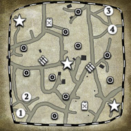
Very well-written article! I love the last part, about how accurate the in game map is to the real locations. Never knew the maps were so accurately modeled. Now, the question is - are there any more maps relic made that are accurate too?
Can't wait for more
Can't wait for more
I am not responsible for anything I say.
6 Aug 2016, 08:38 AM
#11
Posts: 1283 | Subs: 4
Guys!!
Thank you so much! The warm response has been really touching. I'm so glad you enjoyed it!
Certainly a great source of inspiration and a model to follow, mèntore.")
Thank you! Yes, it was certainly an eye raising moment for me as well when firing up the google machine and playing around, seeing the town I was a bit taken aback how similar the shape was haha.
Now that I think about it, I seem to recall a Relic dev diary for vCoH outlining how they made Angoville by comparing satellite and street photography as well as blending in historical images. They chose Angoville 'cos of the wealth of material they had available. I think in attitude that also speaks to the developers love of history and the love of the investigation process which has also helped fuel development. It most certainly isn't just a game to them, but a representation of a time period and human history, and to represent it in a way they feel is charitable I think means a lot to the developers. I know we get lost in balance arguments and bugs and things, but I hope a feature like this also spotlights the love and the talent that gets poured into the creation and the detail in the game.
If you have any suggestions for a map that you would like me to investigate, RealName, I would be more than receptive to hearing them.
I'm glad you enjoyed it, and hope we can provide a similar quality of features in the future. Welcome to COH2.org
Thank you so much! The warm response has been really touching. I'm so glad you enjoyed it!
I love this! Much like my TToH but even better
Certainly a great source of inspiration and a model to follow, mèntore.
Very well-written article! I love the last part, about how accurate the in game map is to the real locations. Never knew the maps were so accurately modeled. Now, the question is - are there any more maps relic made that are accurate too?
Can't wait for more
Thank you! Yes, it was certainly an eye raising moment for me as well when firing up the google machine and playing around, seeing the town I was a bit taken aback how similar the shape was haha.
Now that I think about it, I seem to recall a Relic dev diary for vCoH outlining how they made Angoville by comparing satellite and street photography as well as blending in historical images. They chose Angoville 'cos of the wealth of material they had available. I think in attitude that also speaks to the developers love of history and the love of the investigation process which has also helped fuel development. It most certainly isn't just a game to them, but a representation of a time period and human history, and to represent it in a way they feel is charitable I think means a lot to the developers. I know we get lost in balance arguments and bugs and things, but I hope a feature like this also spotlights the love and the talent that gets poured into the creation and the detail in the game.
If you have any suggestions for a map that you would like me to investigate, RealName, I would be more than receptive to hearing them.
Great job mate, thanks
I'm glad you enjoyed it, and hope we can provide a similar quality of features in the future. Welcome to COH2.org
6 Aug 2016, 20:32 PM
#12
 9
9 
Posts: 1194 | Subs: 29
Good stuff. Nice comparison between the minimap and real life overhead view.
Playercard of tightrope | ||||||||||||||||||||
|
7 Aug 2016, 22:03 PM
#13
Posts: 276
If you have any suggestions for a map that you would like me to investigate, RealName, I would be more than receptive to hearing them.
I have a suggestion -- Across the Rhine, my favorite map, with its beach and the stone bunkers and all.
Trois Ponts and Moscow Outskirts look like they are based off real life too, they'd be interesting to see.
I am not responsible for anything I say.
8 Aug 2016, 14:26 PM
#14

Posts: 1166 | Subs: 1
This is unreal!! Great work turbo and please keep em' coming!
8 Aug 2016, 14:33 PM
#15
Posts: 1138 | Subs: 2
I have a suggestion -- Across the Rhine, my favorite map, with its beach and the stone bunkers and all.
Not sure what the text in the loading screen says, but since this was added with Brits I assumed this is supposed to resemble the Rhine at Wesel, where the UK crossed. In that case, it's purely fictional as you'd have to dig hundreds of meters deep to find anything but sand and mud...
9 Aug 2016, 13:21 PM
#16
Posts: 21
please do more! I love stuff like this!
11 Aug 2016, 14:51 PM
#17
Posts: 1283 | Subs: 4
I have a suggestion -- Across the Rhine, my favorite map, with its beach and the stone bunkers and all.
Trois Ponts and Moscow Outskirts look like they are based off real life too, they'd be interesting to see.
Mmmm! Interesting, Moscow certainly piques my interest,
... not on the Eastern Front.
I found a great archive of aerial imagery here! remarkable for it's use both during and post-war in the hands of the allies, but I do not think it has bee digitized or categorized in anyway that would be accessible unless in person

which actually now brings up the issue of researching Eastern Front locales that may have experienced large degrees of change, such as Moscow.
 I was able to get away with modern imagery for sleepy La Gleize.
 Trois Ponts, could be interesting but I would run the risk of covering the same area twice, or even being accused of western front bias haha. I'm going to give Moscow a little more thought though. See if I can't find some imagery.
14 Aug 2016, 16:31 PM
#18

Posts: 88 | Subs: 1
Cool stuff. Although it's Peiper not Pieper and Greif not Grief I believe.
16 Aug 2016, 10:18 AM
#19
 1
1 Posts: 1021 | Subs: 1
very nice read! but wtf is "rollbahn" ?? i have never seen this word used in this context, its normally a part of an airport, the part where planes drive to the terminals to be exact
“Ha! They're scratching your paint job, Helmut!”
18 Aug 2016, 03:43 AM
#20
Posts: 1283 | Subs: 4
Cool stuff. Although it's Peiper not Pieper and Greif not Grief I believe.
MMMM damn it, yeah you're entirely right, I screwed up adding it to my word dictionary. I got it right the first time in the introduction but from then on flopped, oughhh painful. I'll be more careful in my next article
very nice read! but wtf is "rollbahn" ?? i have never seen this word used in this context, its normally a part of an airport, the part where planes drive to the terminals to be exact
Yeah, it was new for me as well. In this context in the documents I had cited I think the translation or use was something along the lines of "attack road", or route. I'm not sure of the historical accuracy.
18 Sep 2016, 20:16 PM
#21

Posts: 327
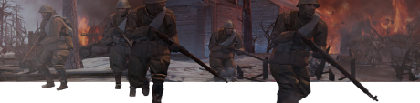
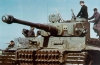
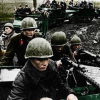
Yeah Peiper's name still shows up wrong all across the piece. Also, the "Tiger 221" photograph shows a Panther, not a Tiger or King Tiger. I'm also not aware of any Tiger Is having been involved in this battle.
Other than that, nice piece. I'm surprised something like this hadn't been done before.
Other than that, nice piece. I'm surprised something like this hadn't been done before.
1 user is browsing this thread:
1 guest
Livestreams
 |
|
|
61 | ||
 |
|
|
37 | ||
|
|
|
|
1 |
Ladders Top 10

-
#Steam AliasWL%Streak
- 1.48570.874+9
- 2.817140.854-1
- 3.1140404.738+12
- 4.1404769.646+1
- 5.564352.616+11
- 6.23359.798+10
- 7.450228.664+1
- 8.11930.799+6
- 9.348124.737+2
- 10.430306.584-1
Data provided by
 Relic Entertainment
Replay highlight
VS
-
 cblanco ★
 -
 보드카 중대
-
 VonManteuffel
 -
 Heartless Jäger
Einhoven Country


Honor it
18
Download
3333
Board Info
777 users are online:
1 member and 776 guests
educationaltoursglob
educationaltoursglob
0 post in the last 24h
5 posts in the last week
19 posts in the last month
5 posts in the last week
19 posts in the last month
Registered members: 69607
Welcome our newest member, educationaltoursglob
Most online: 4501 users on 26 Oct 2025, 01:00 AM
Welcome our newest member, educationaltoursglob
Most online: 4501 users on 26 Oct 2025, 01:00 AM